top of page
Spatial planning
Warning
We offer absolutely no waranty for the quality of the maps that are presented here. Indeed, these maps are a preliminary result of a work in progress and they need to be enhanced with more complex methods and evaluated with an independent dataset.
These maps were released before their quality could be thoroughly evaluated because of the current French situation in wind turbine development and the urgent need to take biodiversity into acount during spatial planning.
Goal of the maps
These maps aim at presenting the areas of conservation priority for each bat species at the French scale.
Method used to build maps
The method to predict bat acoustic activity is explained here. We applied this method to predict bat activity every two weeks of the year between march and october. Then, we considered the value of each pixel of France taken during the different periods of the year. Indeed, bats are more active during certain months (ex: some migrating bats are often more active in autumn than in spring, but some resident bats are sometimes more active in summer than in autumn). We kept only the value of the period with the highest activity during the year.
How to read the maps
The colour indicate the level of activity. For spatial planning at a regional scale, it is important to consider the species' activity at the location of interest relatively to the activity of the same species at the regional scale. For instance, a municipality in the Region "Hauts de France" should not compare its activity with the activity in Corsica, but with other municipalities in Hauts de France.
Low activity
High activity
Moderate activity
Very high activity
Species sensitivity to wind turbines and migration status
This table shows the sensitivity of bats to wind turbine collisions and their migratory status. Migrating bats are especially sensitive to collisions because they cross many wind turbines on their way.
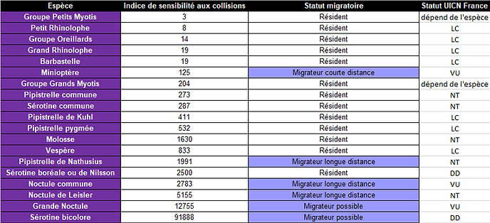
The index of sensitivity to wind turbine collisions is from Roemer et al., 2017.
Download maps
Some species are difficult to study (acoustic identification is difficult, or the species is especially rare). Therefore, the maps are not available for all species.
PDF format:

SHP format:
This work was funded by the French Office for Biodiversity.
Recommanded citation :
C Roemer, Y Bas & C Kerbiriou (2023, June) Maps of bat activity for spatial planning. Muséum national d'Histoire naturelle. Retrieved from https://croemer3.wixsite.com/teamchiro/spatial-planning
bottom of page